Fire activity continues to decline in Yellowstone National Park, with none of the five active blazes showing growth from yesterday.
As a refresher, here are the acreages of each fire around Yellowstone as they stand currently:
• Maple Fire: 41,136 acres.
• Buffalo Fire: 10,787 acres.
• Fawn Fire: 2,684 acres.
• Central Fire: 1,350 acres.
• Jasper Fire: 1 acre.
Earlier today, officials removed Stage 2 Fire Restrictions from Yellowstone National Park, leaving Stage 1 restrictions in place.
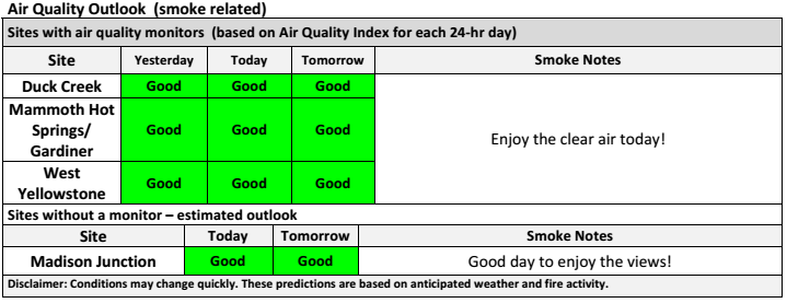
Air quality has also shot up, especially in the Duck Creek area and West Yellowstone, which was previously hit with unhealthy amounts of smoke. See the full table below.
A fire meeting is scheduled at the LDS Church, 245 Faithful Street, West Yellowstone, MT, at 7:30 p.m. Thursday, September 8. The same day, crews will perform a burnout operation at Bakers Hole on the Madison River.
However, according to a Yellowstone press release, after the burst of cool, wet weather this weekend, warm days and low relative humidity have started to dry out light fuels around the Park. Heavier fuel, like downed logs, did not absorb much moisture and can still carry flame.
In spite of this, the changes around the Park are readily apparent. One of the biggest changes: Maple Fire’s east side has quieted down considerably and no longer threatens Madison Junction or Norris Geyser Basin. Sprinklers and hoses are being removed from both areas. Crews continue to patrol Maple Fire’s edges.
Officials have also downsized Maple Fire’s closure area. Effective today, the Harlequin Lake and Purple Mountain trails have reopened.
Mount Holmes, Grizzly Lake, Winter Creek, and Trilobite Lake trails have also been removed from the closure area. However, due to road construction, the trailheads of each will remain closed. Please call the Backcountry Office at 307-344-2160 for more information on accessing these trails.
Crews continue to work on the Buffalo Fire, patrolling the fire’s east side, which can sometimes be seen from the Mount Washburn Fire Lookout – Northeast Webcam.
Fawn, Central and Jasper Fires are unstaffed at this time and will be monitored by the air.
Below is the full list of trail and campsite closures in Yellowstone, including those in nearby Custer Gallatin National Forest:
• From the intersection of Highway 191 and Duck Creek Road #2523 (south side of the road), to Yellowstone National Park boundary, including the fishing access road at the end of Duck Creek road, south along YNP line to the north side of the Madison River bluff, then north along east side of Highway 191 back to the starting point, excluding the transfer station and road #6794
Campsites
• Slough Creek Campground
• WA1
• 1C1
• 1C2
• 1C4
• 1C5
• WB1
• WB3
• WB4
• WB6
• 2S1
• 2S2
• 2S3
• 2S4
• 2S6
• 2S7
• 2S8
Trails
• Mary Mountain Trail (including Mary Lake Patrol Cabin).
• Old Airport Road in West Yellowstone.
• Riverside Trail.
• Cougar Creek Trail.
• Slough Creek trail and “associated Day Use area.”
• Bliss Pass Trail between Slough Creek and Pebble Creek trail.
• Buffalo Fork Trail from the trailhead at Slough Creek to the Park Boundary.
• Gneiss Creek Trail from the Gneiss Creek Trailhead (WK7) to Seven Mile Bridge Trailhead (WK8).
• Bighorn Pass trail eastbound at the junction of the cut-off trail to the Fawn Pass trail.
• Bighorn Pass trail westbound at Bighorn Pass.
• Fawn Pass trail eastbound at the junction of the cut-off trail to the Big Horn Pass trail.
• Fawn Pass trail westbound at campsite 1F2.
All park roads and visitor facilities, both NPS- and concessionaire-operated, are open at this time. Seasonal closures have started to go into effect, especially around Tower/Roosevelt.
 Yellowstone Insider Your Complete Guide to America's First National Park
You must be logged in to post a comment.