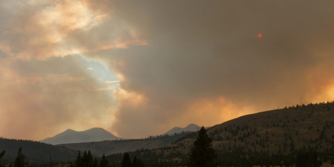
Maple Fire has grown to approximately 35,000 acres and has prompted more trail and campsite closures.
According to a Yellowstone press release, Maple Fire now measures 34,968 acres. We previously reported Maple Fire was 33,058 acres in size. Crews say it showed significant activity in the northwest corner; air support responded with water drops. In addition, a Chinook helicopter and a smaller type 2 helicopter were deployed in the Cougar Creek area. Two “Fire Bosses” were flown into the Gneiss Creek area.
Today, crews will lay down hoses in the Cougar and Gneiss Creek areas to support potential burnout operations. Fire containment lines have been installed in the former Boundary Fire area. Crews add that the north and east flanks will show more activity today.
The fire is currently visible from the West Entrance Road. At this time, the road is still open to visitors. Fire information personnel are on site and are available to answer questions. In addition, crews will be performing burnout operations in the 7 Mile Bridge area and preparing “an anchor point” along the southern flank of the fire, near the Madison River.
Crews continue to work on fuels reduction projects in the vicinity of West Yellowstone and the Duck Creek subdivisions. Fuel reduction and structure protection measures (including sprinkler systems) have been installed at Madison Junction and Norris Geyser Basin.
We previously reported that Central Fire had grown to 866 acres. According to a Yellowstone press release, it’s actually 840 acres. There are no other changes to report at this time.
The acreages for Buffalo and Fawn Fires have not changed since our last report.
Stage 1 fire restrictions are still in place for Yellowstone National Park. Below is the full list of trail and campsite closures, including sites in Custer Gallatin National Forest.
• From the intersection of Highway 191 and Duck Creek Road #2523 (south side of the road), to Yellowstone National Park boundary, including the fishing access road at the end of Duck Creek road, south along YNP line to the north side of the Madison River bluff, then north along east side of Highway 191 back to the starting point, excluding the transfer station and road #6794
Campsites
• Slough Creek Campground
• WA1
• 1C1
• 1C2
• 1C4
• 1C5
• WB1
• WB3
• WB4
• WB6
• 2S1
• 2S2
• 2S3
• 2S4
• 2S6
• 2S7
• 2S8
Trails
• Old Airport Road in West Yellowstone.
• Purple Mountain Trail.
• Riverside Trail.
• Cougar Creek Trail.
• Harlequin Lake Trail.
• Mount Holmes Trail.
• Winter Creek Trail.
• Grizzly Lake Trail.
• Trilobite Lake Trail.
• Slough Creek trail and “associated Day Use area.”
• Bliss Pass Trail between Slough Creek and Pebble Creek trail.
• Buffalo Fork Trail from the trailhead at Slough Creek to the Park Boundary.
• Gneiss Creek Trail from the Gneiss Creek Trailhead (WK7) to Seven Mile Bridge Trailhead (WK8).
• Bighorn Pass trail eastbound at the junction of the cut-off trail to the Fawn Pass trail.
• Bighorn Pass trail westbound at Bighorn Pass.
• Fawn Pass trail eastbound at the junction of the cut-off trail to the Big Horn Pass trail.
• Fawn Pass trail westbound at campsite 1F2.
• The cut-off trail between Bighorn and Fawn Pass trails is open.
All park roads (including the South Entrance) and visitor facilities, both NPS- and concessionaire-operated, are open at this time.
 Yellowstone Insider Your Complete Guide to America's First National Park
