Most of the Yellowstone Lake islands aren’t broadly noteworthy in Yellowstone National Park’s history, with the exception of Dot Island.
Dot Island was the site of a zoo, run by one E.C. Waters, who kept bison and elk in pens there. Visitors could take a boat from West Thumb, which also ran to Lake Hotel. The zoo only ran from 1896 to 1907; the zoo closed due to changing attitudes in national park etiquette, and more importantly, to prevent any more mistreatment of the Dot Island animals.
Ironically, in spite of Dot Island’s importance to Yellowstone’s visitation history, it was all but unimportant to the body that named it and the other Yellowstone Lake islands: the 1871 Hayden Geological Survey.
Indeed, all seven (technically eight, but we’ll get to that later) named Yellowstone Lake islands received their name from the Hayden Survey.
Carrington Island
A couple miles northeast of Bluff Point, this island was named for zoologist E. Campbell Carrington, who had previously worked with Ferdinand Vandeveer Hayden on a 1869 survey of the Colorado and New Mexico Territories. In Yellowstone, according to Lee H. Whittlesey’s Yellowstone Place Names, he studied Mud Geyser, took notes on a cutthroat trout worm, and helped name/sketch features along the Yellowstone Lake shoreline.
Dot Island
According to Whittlesey, Dot Island was named because its size, “a mere dot on the map” (90). Besides the Waters zoo, there is not much else noteworthy about this speck of land, located east of West Thumb.
Frank Island
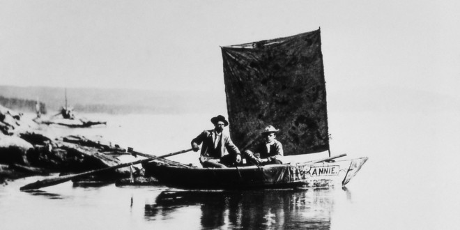
The largest island on Yellowstone Lake, Frank Island was named for Henry Wood Elliott, who toured the lake in the Survey’s boat, “Annie,” alongside Carrington. Curiously, according to Whittlesey, an initiative sought to rename the island “Belknap,” in honor of then Secretary of War William W. Belknap; it never came to pass.
Visitors to Yellowstone National Park are allowed to camp on Frank Island, in accordance with all backcountry regulations and site-specific rules. The island is northwest of Promontory Bay, north of the Flat Mountain Arm of Yellowstone Lake, and east-northeast of Wolf Bay.
Molly Islands
Technically, there are two Molly Islands, but they’re so small and so close—practically adjacent, measuring just over half an acre to almost one-and-a-quarter acres together—that there’s no obvious reason to name them separately although, according to Whittlesey, the individual islands are named Sandy and Rocky. They can be found in the Southeast Arm of Yellowstone Lake, off the coast of Promontory Peninsula.
There are several Mollys who may be the namesake for this pair. The first, and generally accepted namesake, is Molly Gannett, wife of the Hayden Survey’s chief geographer Henry Gannett, according to Hiram Martin Chittenden. The second supposed namesake, according to Whittlesey, is Mary “Mollie” Greer, wife of Hayden photographer William Henry Jackson—Greer is supposedly the namesake because, as early as 1871-72, the islands were marked as “Mollie Island.” Further, Greer died in February 1872; supposedly, the island was named “Mollie” in her memory. Nonetheless, Chittenden’s assessment holds more credence.
Both historically and currently, the Molly Islands is a haven for nesting bird colonies: pelicans, California gulls, and double-crested cormorants. Boaters must stay at least a quarter-mile away from Molly Islands at all times.
Peale Island
Albert Charles Peale was one of the more prominent members of the 1871 Hayden Geological Survey, renowned as both a doctor and a mineralogy expert, integral to both Yellowstone place naming as well as Yellowstone’s thermal history. His journals constitute a great deal of Marlene Deahl Merrill’s excellent compendium, Yellowstone and the Great West. Peale Island is located in the South Arm of Yellowstone Lake, closer to the shore.
Whittlesey shares an amusing anecdote in his entry on Peale Island, citing one of geologist Arnold Hague’s notebooks. According to Hague, when he visited the island in 1891, he was greeted by the island’s (apparently lone) resident, a rabbit: “He turned up at different parts of the island wherever we happened to go, and seemed much astonished that anyone should have invaded his island home.”
Pelican Roost
A small and rocky island, there is not much to this island’s history besides the name. It is located between Steamboat Point and Mary Bay.
Stevenson Island
James Stevenson served as Hayden’s assistant from 1866 to 1879; supposedly (according to Whittlesey) the two met far earlier in 1853, when Hayden was touring the Dakota badlands and encountered Stevenson, then a 13-year-old runaway. Stevenson was, according to Hayden, “undoubtedly the first human that ever set foot upon it,” although (according to Merrill) the party also discovered a white flint spearhead on the western shore, indicating that Native Americans may have at least visited if not stayed there. The island can be found two miles south of Lake Village, east of Gull Point.
 Yellowstone Insider Your Complete Guide to America's First National Park
You must be logged in to post a comment.