Yellowstone National Park just got a nifty way to assess what roads need resurfacing in the Park, courtesy of the Sanborn Map Company, Inc.
Sanborn, based out of Colorado Springs, CO, recently completed two surveys of Yellowstone and Glacier National Park, collecting data on what portions of each Park needs roadwork done. Indeed, according to a press release, Yellowstone has around 185 miles of roads that are “in a structurally deficient state, with poor quality road bases failing under the weight, speed and volume of modern traffic, for which they were not designed.”
Given the record number of visitors who have been coming to the Park the past few years, this is hardly surprising. Sanborn also notes most of the roads have been ravaged by harsh winters. And since Yellowstone has such a short construction season, it’s hard to keep up some years. From a Sanborn press release:
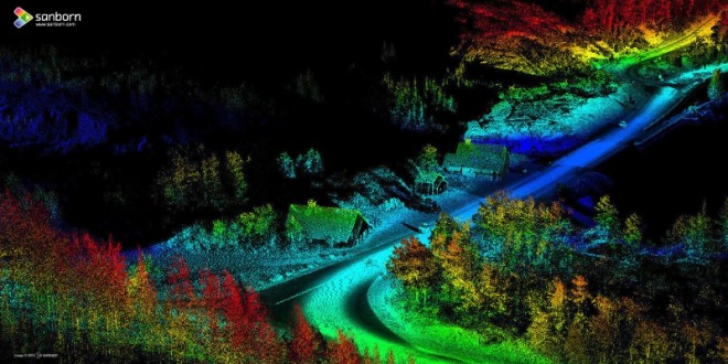
During the 2015 fall season, Sanborn acquired the LiDAR point clouds, which were particularly dense with 300-500 points per square meter, along with accompanying georeferenced imagery. The firm’s post-acquisition approach involved auto-filtering the point clouds in the ground and non-ground classes. The points in the ground class were used to derive road centerlines and edges of pavement, and the non-ground points were used to derive guardrails in vector format.
“This project was particularly rewarding because both of these parks truly are national treasures,” notes Arjan Mooij, Sanborn program manager. “There’s no doubt that the quality data we provided will help streamline the process for their much-needed road repairs.”
Sanborn has been in the cartography business since 1867, beginning with fire insurance atlases of major cities in the United States, now valued for their vast research applicability. Today, they provide a multitude of services in a variety of fields, including aerial imagery and geospatial data.